
If we want to understand the full picture of climate-fueled flood risk to New York City, we can’t just look at rainfall.
by Arielle Samuelson, Heated
If you read the news or scrolled social media this weekend, you probably heard that New York City experienced record-breaking rainfall and catastrophic flooding on Friday.
You probably heard that LaGuardia Airport shut down a terminal; that subway lines transformed into cesspools; that a whirlpool formed in Brooklyn; that a sea lion escaped its enclosure in the Central Park Zoo.
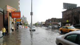
But what you may not have heard, as I hadn’t before yesterday, is that scientists who study coastal flooding actually consider Friday’s flood to be “mild.” That’s because, while the rainfall itself was record-breaking—more than 8.65 inches fell at JFK airport—the coastal flood level was only two feet above high tide.
That level of flooding is classified as an annual flood, said Kelly Van Baalen, project manager of Climate Central’s sea level rise team. “The numbers on the rainfall are a piece of it, but you would expect coastal flooding of this sort every year,” she said.
Recent Posts

Have We Advanced Since Homer?
Take Action Now Homer knew war was traumatic. The cartoonish version of war in which killing is easy and surviving is simple is a creation of modern…

THE PLOT AGAINST THE MIDTERMS
Take Action Now With the Democratic establishment in disarray, Trump and his deputies plan to meddle with the election to keep Congress splitBy…

Rubio’s Paranoid Cuba Report Designed to “Justify a Military Attack on Cuba,” Says Democratic Rep.
Take Action Now Did Cuba foment Black Lives Matter and anti-ICE protests? The State Department seems to think so.By Noah Hurowitz, The Intercept A…
The State’s War on the Left Didn’t Begin With Trump — But He’s Escalating It
Take Action Now Trump’s war on the left blends “war on terror” language with Cold War McCarthyism.By Chip Gibbons, Truthout The Trump…